WP1 Collection of reference data for yield modeling
Work Package Objective: The main objective of work package 1 was to prepare a suitable set of reference data for the implementation of subsequent work packages aimed at analyzing grass growth conditions and yield modeling. The reference data included two types of information – soil-plant parameters measured in situ and meteorological data.
Work package results:
A baseline dataset was prepared for subsequent work packages aimed at grass growth status analysis and yield modeling.
Reference data was prepared based on two types of information – soil and plant parameters measured in situ and meteorological data.
A review of the progress of the project objectives, including achievements, milestones and results
identified in the project agreement.
As a result of the work package, the following was realized:
Description of the results achieved during the reporting period, activities carried out during the reporting period.
The meteorological base was supplemented with readings from 2023. The same parameters as in previous years were adopted. Data were taken both for the study areas (NUTS Podlaskie, NUTS Wielkopolska and the study area in Norway) and for individual study areas.
A database of in situ measurements was created. It was supplemented with documentation collected during the fourth year of field campaigns. The database was created in .xls and .csv format and organized. The database was also supplemented with satellite measurements, average values of remote sensing vegetation indices for each field.
Ground measurements continued in selected fields in Poland, especially in the Wielkopolska and Podlaskie regions. Field campaigns were conducted by IGIK and PULS. Meanwhile, within NORCE and NIBIO, calibration models estimated from ground measurements were tested and verified
in previous years. The full database was validated at the end of the project in 2023. In situ measurements were carried out on plots of land indicated by individual farmers.
WP2 Classification of grassland types based on satellite data
Work Package Objective: The main objective of Work Package 2 was to prepare grassland classification maps for selected test areas, with a general distinction between high-productivity grasslands and low-yield, unimproved grasslands. The approach to classification will be based on the use of time series of Sentinel-2 satellite data to distinguish between meadow types. The classification maps were necessary for further grassland yield modeling work and for proper establishment of the ground survey network.
Results of the work package: Grassland classification
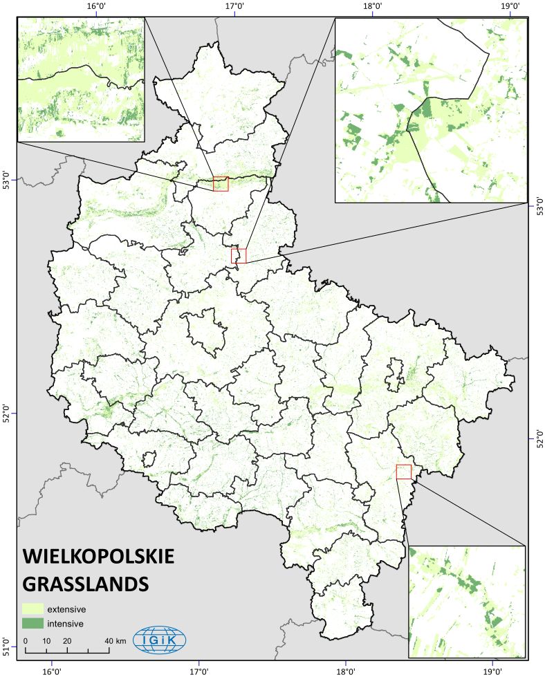
As part of the work conducted, a classification of grasslands was performed. The developed classification maps were prepared for the selected test areas, with the general division into high-productive grasslands and low-yielding unimproved grasslands. The classification approach was based on applying time series of high-resolution Sentinel-2 satellite data for discrimination of grassland types.
At first stage of the works, High Resolution Layer (HRL) existing within Copernicus service was applied, in order to delineate grassland areas for the selected test sites. Next, series of cloud-free Sentinel-2 images were collected for the regions of interest. It was decided to select the March 2020 and 2021 images. Grassland areas were extracted from S-2 images using masks prepared on the basis of HRL layer. The Random Forest classification method was applied using R programming language. The classification approach was based on information from farmers and advisory service regarding botanical composition and age of grassland as in situ data, then analyses of time series of vegetation indices calculated from high-resolution Sentinel-2 satellite data. There were over 500 test plots designated for each class. These were divided in a 50:50 ratio.
The aim of classification procedure was to discriminate two basic types of grasslands:
• High productive grasslands, which are situated on good or medium quality soils, used with more frequent defoliations, higher fertilization rates, higher stocking rates and producing higher yields than semi-natural grasslands
• Low-yielding unimproved permanent grasslands, which are dominated by indigenous, naturally occurring grass communities and other herbaceous species resulting in high biodiversity
The classification was made into Podlaskie and Wielkopolskie voivodships. The overall accuracy for Podlaskie was 97,6%, while for Wielkopolska was 86,7%. Percentage share of extensive and intensive grasslands in Podlaskie voivodship is 70:30 and Wielkopolskie voivodship is 75:25.
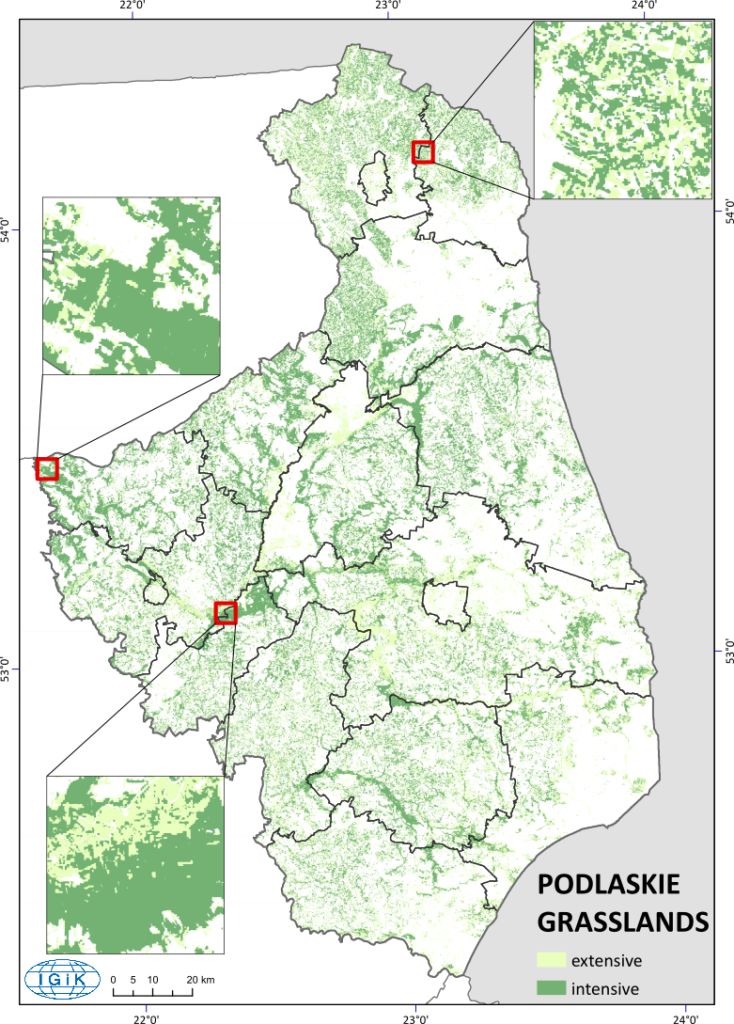
WP3 Using remote sensing indicators to monitor grassland growth
Work Package Objective: The main objective of WP3 was to identify available methods and develop new algorithms for estimating grass growth and other biophysical parameters from high-resolution satellite data for two different environments, Poland and northern Norway.
The main objective was divided into the following tasks:
To determine the relationship between vegetation indices derived from high-resolution satellite data and in situ measurements, obtained in WP1, characterizing grass growth and quality.
. Analysis of (existing) in situ hyperspectral data in relation to reference data, with the aim of developing new yield forecasting models.
Development of a model based on a time series of vegetation indices for yield forecasting in areas with high cloud cover.
To create maps of vegetation parameters for the studied regions during the growing season.
To compare methods and relationships between the 2 study regions to identify similarities and differences between different climates, grass species composition and growing conditions.
Work package results: A comparative analysis of NDVI and NDII vegetation indices for fields in Poland and Norway was carried out, indicating the main similarities and differences. A total of 47 fields in the Podlasie and Greater Poland regions of Poland and 18 fields in four regions of northern Norway (Vesterålen, Malangen, Nordreisa and Målselv/Mid Troms) were monitored.
A time series of NDVI values recorded during the 2020, 2021, 2022 and 2023 growing seasons was used, showing the minimum, average and maximum NDVI values for all fields in the three regions.
WP4 Assessment of grass damage due to adverse weather conditions
Work Package Objective: The main objective of WP4 was to develop methods to determine stressful conditions for grasslands during the growing seasons due to drought conditions, severe winter damage or lack of adequate nutrition. Satellite data and in situ measurements will be used.
The results of the work package:
Analysis of stress conditions for grasslands:
Regions most vulnerable to adverse hydrothermal conditions (Greater Poland and Podlasie) and areas with minimal drought risk (fields in Norway) were identified.
Fields in Norway are characterised by a short, intense growing season and difficult winter conditions.
Calculation of hydrothermal coefficient (HTC):
A complete meteorological database was used to calculate the HTC over 10-day periods.
The HTC results allowed the assessment of drought risk in each region.
Plant growth modeling:
A BASGRA model was used to simulate the growth of forage grasses under different weather conditions, taking into account soil and crop management.
The model made it possible to predict winter freeze events such as frost damage, ice and fungal diseases.
Application of analytical tools:
Satellite data, drone imagery and meteorological data were used for integrated analysis.
The combination of these tools enabled more precise identification of stress factors and risk assessment for grasslands.
WP5 Combining a process-based grassland model and information obtained through satellite remote sensing techniques
The work package was divided into the following tasks:
Calibration of the process grassland model (BASGRA) under drought stress conditions in Poland using different combinations of grassland characteristics data (LAI, site density, biomass yield) that are satellite-derived and from ground recordings.
Calibration of a process-based grassland model (BASGRA) under winter (stressed) conditions in northern Norway using different combinations of grassland characteristics data (site density before and after the winter season), which are of satellite origin and from ground recordings.
Testing the calibrated model on independent data under drought stress conditions in Poland.
Testing the calibrated model on independent data under winter stress conditions in Norway.
Simulation of winter and growing season survival using real-time updates from satellite data.
Results of the work package:
BASGRA model calibration:
1. The BASGRA model was calibrated for the prediction of winter stress and grass frost in grasslands, using satellite data (Sentinel-2) and in-situ observations.
The calibration included a comparison of pre- and post-winter plant cover status, leaf area index (LAI) and aboveground biomass dry weight.
Data from northern Norway, characterized by harsh winter conditions, allowed the model parameters to be adjusted to the specific conditions of the region, increasing the accuracy of the predictions.
Real-time updates:
Real-time updates to the BASGRA model using spring plant density and biomass data have been introduced.
The updated GrasSAT model incorporates data from both ground and satellite observations.
A comparative analysis showed that the spring updates improve the accuracy of biomass forecasts compared to reference simulations.
Impact on forecast accuracy:
The changes and updates made have significantly improved the accuracy of biomass and survival predictions for grasses under various climatic conditions, including winter stress and drought situations.
WP6 Development of a web service/mobile application for grassland management
Work Package Objective: WP6 activities were focused on developing a website dedicated to presenting the project’s results, i.e. information on grass growth conditions, indications of areas affected by drought, winterkill and affected by different management methods (WP4), as well as grass yield forecasts (WP5), drought, freeze-thaw and the impact of different management methods (WP4), and grass yield forecasts (WP5). In parallel, a mobile application will be developed to deliver the same products to individual farmers. The prepared tool will also be useful for organizations responsible for agricultural production – Agricultural Advisory Centers
Agricultural Advisory Services in Poland and Norwegian agricultural advisory services.
Cooperation with leading agricultural associations, such as the “Polish Association of Meat Cattle Producers” (about 3,000 farmers) and the “Polish Association of Milk Producers”, as well as agricultural consultants, will help reach a wide industry audience. This cooperation will be provided by GEOMATIC, an industry partner.
The main purpose of the IT platform is not only to provide data to end users
end users, but also to access the results through APIs in order to disseminate the system to existing systems, such as for manufacturers, but also for public entities. Also importantly, we would like to continue developing the system, opening it up to partners who would like to add things in the future. For this reason, an open structure and API will be crucial. At the final stage of this work package, the results of the project will be demonstrated and disseminated to the user community. The project’s achievements will also be demonstrated through publications in relevant journals and conferences. An interactive website will also be a form of dissemination activities, used to obtain feedback on the usefulness of the tools prepared as part of the project.
Results of the work package:
M6.1: Development of a dedicated website:
Platform addresses: The GrassAT project website, available at https://auth.gsviewer.pl/, and the GrassAT application, available at https://gsviewer.pl/, have been created.
Design and User Interface (UI): An intuitive and modern interface was designed for easy navigation and access to information.
Content Management System (CMS): A system was created to allow regular updates, adding news, events and publications related to the project.
Project Data Integration: The site enables the display of data and results generated by the GrassAT platform in real time through the development of a technical backend.
Security and compliance: Safeguards have been implemented to protect user data and comply with data protection regulations, including GDPR.
Testing and implementation: Functionality, compatibility and performance tests were conducted on various devices and browsers, allowing the site to be made publicly available.
M6.2: Mobile application development:
Requirements analysis: Gathered expectations from stakeholders to ensure the app meets the needs of users, including farmers and agricultural professionals.
UX design: Designed a mobile interface tailored for convenience and easy access, taking into account the specifics of agricultural work.
Multi-platform development: An app was developed that is compatible with iOS and
and Android, making it more accessible and reducing development time.
Integration with the GrassAT platform: an API was implemented, allowing users to access real-time data such as crop conditions and yield forecasts.
Key functionalities:
– Real-time monitoring.
– Data visualization.
– Notifications of relevant updates and applications.
– Testing and quality control: Comprehensive functional, usability and performance tests were conducted, ensuring the application’s stability and intuitive operation.
Implementation and user training: The application was published in app stores, and training materials and user support were prepared.
Conclusion: A comprehensive digital solution in the form of a website and mobile application was realized. As a result, the results of the GrassAT project are being effectively communicated and used by the targeted users, including farmers, agribusinesses and government institutions.